|
|
|
|
|
|
|
|
Pressure and Winds |
  |
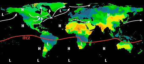
| The figure below shows January and July pressure cells and midlatitude storm tracks superimposed on an average cloud cover map for each month (blue colors show areas of high cloudiness, brown low). | |
|
|
|
|
|
|
|
|
|
|
|
Pressure and Winds |
|
| The figure below shows January and July pressure cells and midlatitude storm tracks superimposed on an average cloud cover map for each month (blue colors show areas of high cloudiness, brown low). | |
|
|
|