Introduction
Topographic Map SymbolsMap Scales (USGS Fact Sheet 015-02)
Historical Maps 1
Historical Maps 2
What is a Topographic Map?
A map represents the surface of the Earth, or part of it. Topographic maps depict the shape of the Earth's surface by contour lines; that is, by lines of equal elevation on the land surface. Contours allow measurements of surfaces to be made directly from topographic maps, such as the heights of mountains or gradients of slopes.A topographic map also includes symbols representing features such as
streets, buildings, and streams. Through time, map symbols were refined
to better show the features they represent, improve map readability, or
to reduce costs.
Within the same series, therefore, maps may have different symbols
for the same feature. Examples of symbols that have changed include built-up
areas, roads, intermittent drainage, and some type styles.
Historically, maps were printed on paper, but they are now often available
in various digital forms on computers. A scan of a printed map creates
a computer file known as a raster file.
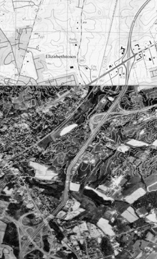
The portion of the Elizabethtown, Kentucky, area shown here demonstrates how map symbols represent features on the Earth's surface. The bottom third, an aerial photograph, shows the Earth as seen from above; the middle part portrays some of the features on the aerial photograph that will be symbolized on the map; and the top third shows the finished map as a digital raster graphic.